


CU GeoData: The World In Our Hands
WHO ARE WE?
CU GeoData is a project team of students who are passionate about integrating the fields of Earth and atmospheric sciences with engineering. We develop and deploy novel instrumentation to record atmospheric, geologic, and hydrologic variables. CU GeoData leverages student knowledge of physical and chemical processes to inform our engineering solutions.
WHY CONTRIBUTE?
With the combined interdisciplinary knowledge and skills of our team members, CU GeoData is uniquely positioned to address complex environmental issues. Through collaboration between our team and local community, we aim to develop innovative solutions to the most pressing environmental challenges of our time. Because our projects are focused on the Cornell and broader Ithaca communities, your contribution will help us to better understand, document, and protect our local environment in a tangible way.
Click to learn more about our mission
MEET OUR TEAMS
Air Team
The air team tackles atmospheric chemistry and air quality data as well as improving weather balloon payloads and instrumentation.

The tethersonde
Current Projects:
Tethersonde
Our longest ongoing project is the tethersonde. We send a student-built tethersonde into the lowest 500 feet of the atmosphere to measure how temperature, humidity, and wind speed and direction change with height. Designed for affordability, mobility, and education, the system enables high-resolution observations in many environments. We are able to characterize boundary-layer structure during Finger Lakes lake-effect snow events, capture spatial variations in wind and temperature across local terrain, and support studies of urban-rural contrasts, sea breezes, and convective development.
Weather Stations
We are expanding local weather station networks to collect more surface meteorological data and to better forecast Finger Lakes precipitation.
3D Printing
To connect with the broader scientific community, we have begun building a 3D-printed weather station in an effort to make weather stations and data collection more affordable and accessible in the future.
Past Projects:
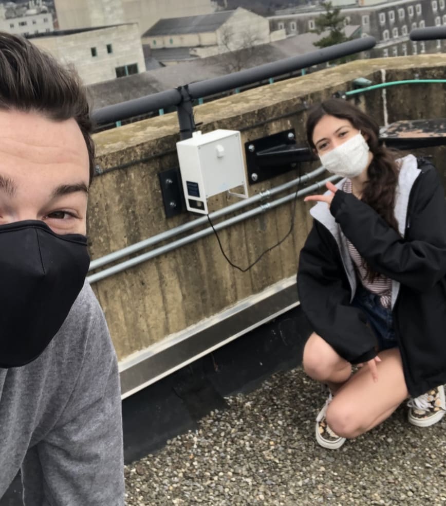
Atmospheric sensor atop Cornell's Snee Hall
Atmospheric Chemistry
The atmospheric chemistry project aimed to install a network of monitoring stations for gathering measurements of local pollutants and their precursor quantities (e.g., ozone, nitrous oxides, and particulate matter). These measurements prompt investigations of possible health risks, topographic features inhibiting pollutant dispersion, and expected meteorological condition-dependent pollutant persistence. We combine this with data from weather stations at the Ithaca Airport and Game Farm Road on Cornell's main campus.
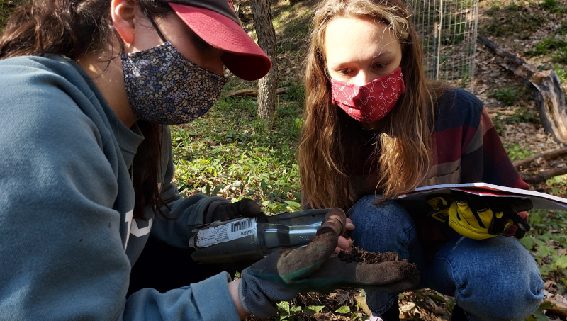
Rock Team

The rock team measures and monitors the quality and stability of soil in our region. Microorganism biodiversity, erosion resistance, agricultural productivity, and conservation of the water table highly depend on soil stability and moisture. The rock team will construct three self-sustaining soil moisture instruments adapted from FreeStation and RaspberryPi builds. Members will then profile basic changes of surface soil under a multitude of moisture conditions through x-ray deflection (XRD).

Land classification map created by Rock Team
Current Projects:
Empire State Mine Tailings Impact Study
With Professor Derry’s lab, we determined the elemental composition of mine tailing samples using inductively coupled plasma mass spectrometry over 2009 to 2019. We also used satellite imagery to develop maps to analyze other environmental factors, including precipitation and air quality. Our goal is to track the local environmental impacts of changes in mine ownership.
Team-Wide Sensor Network
Rock Team, in partnership with local sensor developers and community organizations, is installing a low-cost network of 17 soil moisture sensors and five air quality sensors around Cayuga Lake. Five soil moisture sensors at the Game Farm field site are currently collecting data to ground-truth the NISAR satellite’s soil moisture algorithms. The remaining sensors will be installed in the next two months in preparation for a team-wide lake effect and productivity study.
Water Team

The CU GeoData Water team is a passionate and highly skilled group dedicated to addressing water-related challenges through the power of geospatial data. With a profound understanding of water science and cutting-edge geospatial technologies, our team brings together expertise in hydrology, sensing, and GIS to deliver innovative solutions for water quality assessment, and water resource management. By leveraging advanced geospatial tools and techniques, we aim to empower decision-makers, researchers, and communities in making well-informed choices regarding water management and conservation. Our commitment to sustainability and excellence places the us as leaders in utilizing geospatial data to promote effective water resource stewardship.
Current Projects:
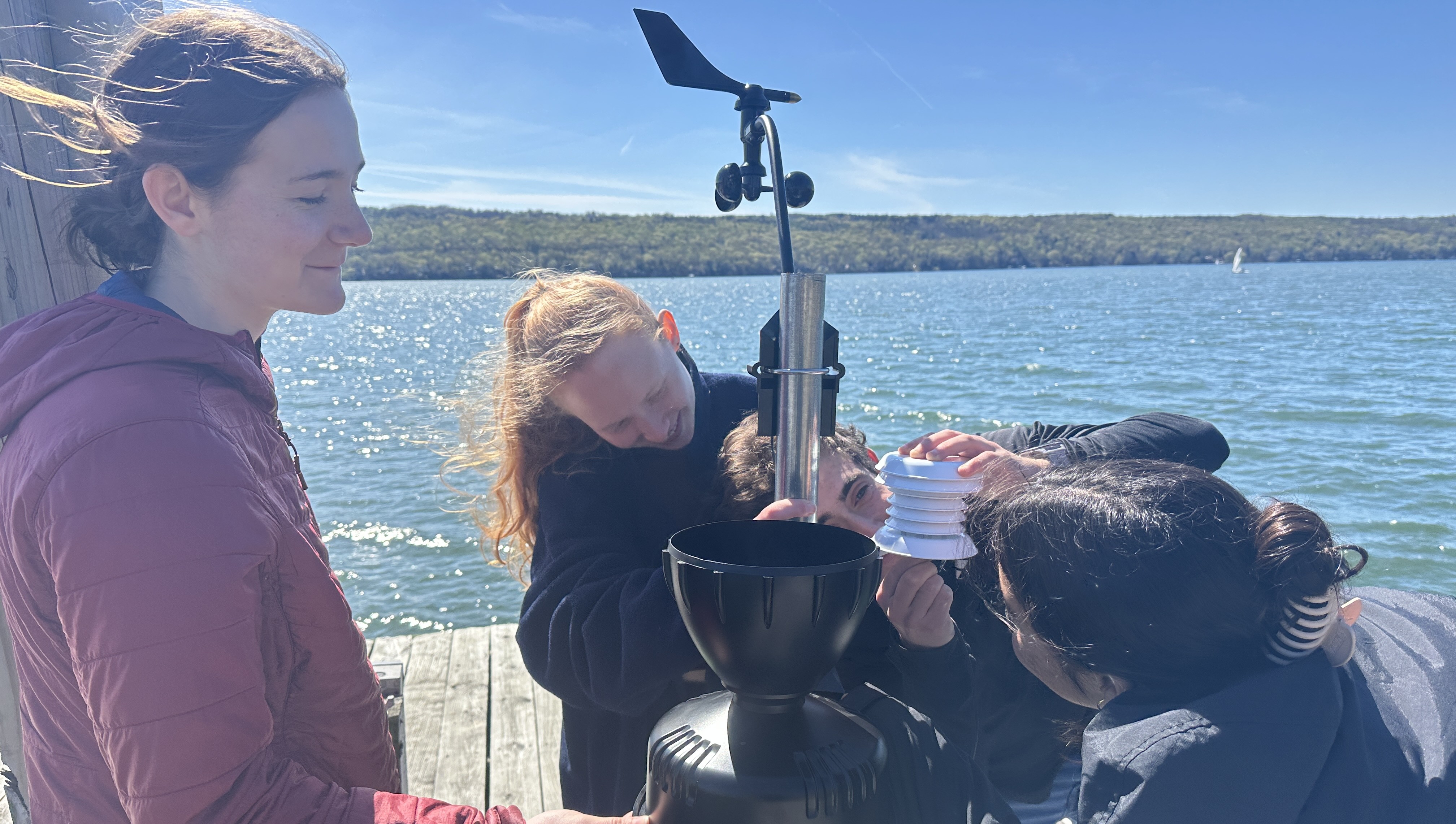
Cayuga Buoy Network
We are currently creating a fleet of buoy weather stations in order to study local Lake Effect Snow across Cayuga Lake. We are using data to increase the accuracy of our predictions.
Sap Sensors
Water team is planning the implementation of Sap Sensors to measure maple transpiration and overall tree health. These sensors will be placed around CNC to study the climatological tendencies of the area through the tree proxy.
Data Loggers
We are experimenting with Internet of Things technology in order to stream the data from our sensors to online servers more efficiently and cost effectively.
Past Projects:
Harmful Algal Bloom Insight
The water team collaborated with the data team to develop a model capable of detecting Harmful Algal Blooms before they occur. In past semesters, we focused on forming strong parameters for the predictor and continuing our instrumental builds in order to house the data ourselves. We also source data from the Citizen Science Institute and the US Geological Survey, which provide a significant amount of data about Cayuga Lake and surrounding watersheds. This allows us to train the HAB predictor model to a high accuracy.
Water Cycle Monitoring
SmartRock Sensor: The water team built our own SmartRock sensor for measuring various water quality parameters in Cayuga Lake.
Micro Hydroelectric Power System: To measure variation in stream velocity in local watersheds, we built a small turbine system to deploy at the Cayuga Nature Center.
Sap Flow Measuring Network: We deployed a Dynamic sap flow system to gain insight into long-term changes in water uptake in the hydrological cycle.
Visualizing Patterns in Cycle
As part of our inner team development, the water team has done Geospatial Information System (GIS) workshops to teach new members how to use services such as QGIS, ArcGISPro, and Google Earth Engine. These allow members to learn new skills relevant to the industry and provide visualizations to demonstrate our data.
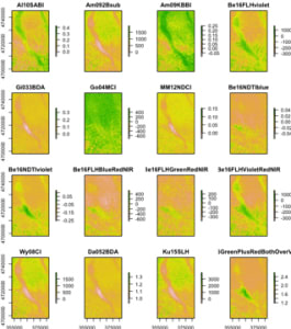
Cayuga Lake harmful algal blooms
Remote Sensing HABs
Harmful algal blooms remote sensing focuses on retrieving satellite data to produce images of present HABs in Cayuga Lake using software in the R programming language called "waterquality". The images give us information regarding color, size, and extent of the HABs. The above image was created using Sentinel 2 satellite data.
Business Team

The business team is responsible for creating promotional material, budgeting, and supply purchasing. We plan yearly and semester budgets, create and maintain sponsorship relations, and work with our team leadership on science communication.
We are also responsible for building community and planning networking and social events for GeoData. We are currently working on designing GeoData merchandise, scheduling social events, expanding our social media presence, and updating our team resume book to share with our sponsors.
Data Team

The Data team is dedicated to providing comprehensive support for all data-related projects within CU GeoData. We thrive in an Agile environment, fostering collaboration and delivering impactful, data-driven solutions to the global community. Our team not only facilitates ongoing projects but also takes initiative with original endeavors aimed at developing innovative data-driven perspectives and promoting the application of Data Science skills.
Current Projects:
Ongoing Work:
We are currently facilitating CU GeoData’s ongoing projects, especially in collaboration with the water team. Project members can take advantage of the existing Machine Learning platforms and resources implemented by the data team.
Past Projects:
Waves
One of data team’s past projects was WAVES Reports, a product that incorporates Generative AI to assist the model pre-processing pipeline of ideally any future Data Science projects. Our aim was to have Wave One and a frontend application go live by the end of the Spring 2024 semester.
Tech Team

Current Projects:
Lake Effect Snow
Over the last few semesters, the Tech Sub-team built a model to predict lake effect snow events on Cayuga Lake. While Great Lakes lake effect events are well-documented and well-studied, Finger Lakes events are less documented and less predictable, largely due to their relative rarity. Because of the lakes’ narrow shape, wind must hit at a specific angle of 300-350° during specific weather conditions to generate Finger Lakes lake effect snow. As a result, there are only a few lake effect events per year. Our model aims to understand and predict these events that generate large amounts of snowfall in our local community.
Drone
We are using a drone equipped with an infrared camera to create a normalized differential vegetation index (NDVI), which is used to measure vegetation health. We also built a synthetic aperture radar to measure topography and soil moisture of the surrounding Finger Lakes region.
WE ARE THANKFUL FOR YOUR SUPPORT AND GENEROSITY TOWARD OUR MISSION!
$20
Circuit Sensor Purchase
This donation allows us to purchase sensors for general use and the testing of environmental data collection instruments, such as the CU GeoData tethersonde.
$50
Hardware Store Trip
This donation allows us to buy the necessary hardware for field research, such as dig sites and instrument build equipment. Save us a trip to the hardware store!
$100
Data Stream Maintenance
This donation allows us continue receiving data from our instrumentation. Donations will be used to maintain sensor connectivity for public data access.
$250
Zynect Soil Moisture Sensor
This donation allows us to measure volumetric soil water content, the data for which will be incorporated into the larger CU GeoData sensor network and used by the Emergent Climate Risk Lab for seasonal drought forecasting. The sensor will be named in donor's honor.
$490
2 Essential Well Water Tests
This donation allows us to conduct EPA certified water testing for over 52 analytes, such as heavy metals, fertilizer contamination, and bacteria. This data will be used to monitor water health in vulnerable Tompkins county areas.
$500
BRONZE
- You will have access to the GeoData team member resume book for recruiting and networking. - Your organization name and logo will be displayed on our website and social media.
$1,000
SILVER
- You will receive a semesterly newsletter with updates on our team and projects. - Your organization name and logo will be displayed on our visual aids at scientific talks and presentations. - A 3D printed funding acknowledgment plaque with your organization name and logo will be displayed on any soil moisture sensor we deploy with your donation
$1,100
Air Quality Sensor
This donation allows us to measure temperature, relative humidity, barometric pressure, carbon dioxide concentrations, particulate matter, and volatile organic compounds and will be used to make real-time air quality decisions during summer wildfires and track seasonal vegetation health. The sensor will be named in donor's honor, for which the data is publicly visible on Air Quality Egg Website: https://airqualityegg.com/portal/
$2,500
Basic Weather Station
This donation will allow us to deploy an additional weather station. Each weather station measures temperature, relative humidity, wind speed and relative direction, and precipitation, which is then used to supplement the existing Northeast Weather Association weather station network. Collected data is used for research and New York State integrated pest management. Station will be named in donor's honor, for which the data will be accessible on the NEWA website: https://newa.cornell.edu/
$2,500
GOLD
- Your logo will be displayed on our apparel. - Representatives from your organization or company have the option of joining priority meetings with team members to discuss our projects. - CU GeoData can host information sessions about your company that are open to members and the greater Cornell community.
$3,500
LEGACY
An Onset weather station or Nexsens weather station buoy will be purchased and deployed in the Ithaca community along with a plaque displaying your company name and logo.